


Voting Districts not defined, Rockingham County, New Hampshire
About
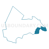
Outline

Summary
| Unique Area Identifier | 616427 |
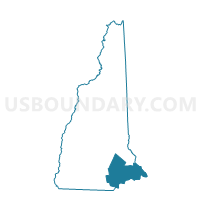
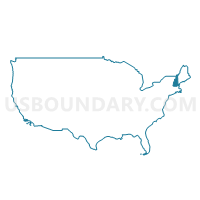
| Name | Voting Districts not defined |
| County | Rockingham County |
| State | New Hampshire |
| Area (square miles) | 43.62 |
| Land Area (square miles) | 0.00 |
| Water Area (square miles) | 43.62 |
| % of Land Area | 0.00 |
| % of Water Area | 100.00 |
| Latitude of the Internal Point | 42.95687050 |
| Longtitude of the Internal Point | -70.63523250 |
Maps
Graphs
Select a template below for downloading or customizing gragh for Voting Districts not defined, Rockingham County, New Hampshire


Neighbors
Neighoring Voting District (by Name) Neighboring Voting District on the Map
- Salisbury Precinct 2, Essex County, MA
- TOWN OF HAMPTON Voting District, Rockingham County, NH
- TOWN OF NORTH HAMPTON Voting District, Rockingham County, NH
- TOWN OF RYE Voting District, Rockingham County, NH
- TOWN OF SEABROOK Voting District, Rockingham County, NH
- Voting Districts not defined, York County, ME
- Voting Districts not defined, Essex County, MA
Top 10 Neighboring County Subdivision (by Population) Neighboring County Subdivision on the Map
- Hampton town, Rockingham County, NH (15,430)
- Kittery town, York County, ME (9,490)
- Seabrook town, Rockingham County, NH (8,693)
- Salisbury town, Essex County, MA (8,283)
- Rye town, Rockingham County, NH (5,298)
- North Hampton town, Rockingham County, NH (4,301)
- County subdivisions not defined, Rockingham County, NH (0)
- County subdivisions not defined, Essex County, MA (0)
Top 10 Neighboring Place (by Population) Neighboring Place on the Map
Top 10 Neighboring Elementary School District (by Population) Neighboring Elementary School District on the Map
- Hampton School District, NH (15,430)
- Seabrook School District, NH (8,693)
- Rye School District, NH (5,298)
- North Hampton School District, NH (4,301)
Top 10 Neighboring Secondary School District (by Population) Neighboring Secondary School District on the Map
Top 10 Neighboring Unified School District (by Population) Neighboring Unified School District on the Map
- Triton School District, MA (20,805)
- Kittery, ME (9,490)
- School District Not Defined (Water), NH (0)
- School District Not Defined (Water), MA (0)
Top 10 Neighboring State Legislative District Lower Chamber (by Population) Neighboring State Legislative District Lower Chamber on the Map
- First Essex District, MA (41,982)
- State House District 13, Rockingham County, NH (25,862)
- State House District 15, Rockingham County, NH (15,430)
- State House District 14, Rockingham County, NH (13,867)
- State House District 18, Rockingham County, NH (6,266)
- State House Districts not defined, MA (0)
- State House Districts not defined, ME (0)
Top 10 Neighboring State Legislative District Upper Chamber (by Population) Neighboring State Legislative District Upper Chamber on the Map
- First Essex District, MA (170,805)
- State Senate District 23, NH (56,793)
- State Senate District 24, NH (53,314)
- State Senate Districts not defined, MA (0)
- State Senate Districts not defined, ME (0)
Top 10 Neighboring 111th Congressional District (by Population) Neighboring 111th Congressional District on the Map
- Congressional District 1, ME (668,515)
- Congressional District 1, NH (657,984)
- Congressional District 6, MA (650,161)
Top 10 Neighboring Census Tract (by Population) Neighboring Census Tract on the Map
- Census Tract 710, Rockingham County, NH (5,298)
- Census Tract 630.02, Rockingham County, NH (4,965)
- Census Tract 660, Rockingham County, NH (4,301)
- Census Tract 2671.01, Essex County, MA (3,573)
- Census Tract 650.05, Rockingham County, NH (2,469)
- Census Tract 650.07, Rockingham County, NH (1,842)
- Census Tract 650.08, Rockingham County, NH (1,718)
- Census Tract 650.06, Rockingham County, NH (1,527)
- Census Tract 9900, Rockingham County, NH (0)
- Census Tract 9901, Essex County, MA (0)